Gilgit-Baltistan (/ˌɡɪlɡɪt ˌbɔːltɪˈstɑːn, -stæn/; Urdu: گِلگِت بَلتِسْتان,[10] Balti: རྒྱལ་སྐྱིད་ སྦལྟི་ཡུལ།[citation needed]), formerly known as the Northern Areas,[11] is a region administered by Pakistan as an administrative territory, and constitutes the northern portion of the larger Kashmir region, which has been the subject of a dispute between India and Pakistan since 1947, and between India and China since somewhat later.[12] It is the northernmost area administered by Pakistan.[13] It borders Azad Kashmir to the south, the province of Khyber Pakhtunkhwa to the west, the Wakhan Corridor of Afghanistan to the north, the Xinjiang region of China, to the east and northeast, and the Indian-administered union territories Jammu and Kashmir and Ladakh to the southeast.


Gilgit-Baltistan is part of the greater Kashmir region, which is the subject of a long-running conflict between Pakistan and India. The territory shares a border with Azad Kashmir, together with which it is referred to by the United Nations and other international organisations as "Pakistan administered Kashmir".[note 1] Gilgit-Baltistan is six times the size of Azad Kashmir.[18] The territory also borders Indian-administered union territories Jammu and Kashmir and Ladakh to the south, and is separated from them by the Line of Control, the de facto border between India and Pakistan.
The territory of present-day Gilgit-Baltistan became a separate administrative unit in 1970 under the name "Northern Areas". It was formed by the amalgamation of the former Gilgit Agency, the Baltistan district and several small former princely states, the largest of which were Hunza and Nagar.[19] In 2009, it was granted limited autonomy and renamed Gilgit-Baltistan through the Self-Governance Order signed by President of Pakistan Asif Ali Zardari, intended to also empower the people of Gilgit-Baltistan. However, scholars state that the real power rests with the governor and not with the chief minister or elected assembly.[20][21] Much of the population of Gilgit-Baltistan wants it to become a fifth province of Pakistan and opposes integration with Kashmir.[22][23] The Pakistani government has rejected Gilgit-Baltistani calls for provincial status on the grounds that granting it would jeopardise its demands for the entire Kashmir issue to be resolved according to UN resolutions.[24] However, in November 2020, Pakistani prime minister Imran Khan announced that Gilgit-Baltistan would attain provisional provincial status after the 2020 Gilgit-Baltistan Assembly election, a long-standing demand of the people of Gilgit-Baltistan.[25][26][27]
Gilgit-Baltistan covers an area of over 72,971 km2 (28,174 sq mi)[5] and is highly mountainous. It had an estimated population of 1.249 million in 2013[28][29] (estimated as 1.8 million in 2015 by Shahid Javed Burki (2015)). Its capital city is Gilgit (population 216,760 est). Gilgit-Baltistan is home to five of the "eight-thousanders" and has more than fifty peaks above 7,000 metres (23,000 ft). Three of the world's longest glaciers outside the polar regions are found in Gilgit-Baltistan. The main tourism activities are trekking and mountaineering, and this industry is growing in importance.
Early history

The rock carvings found in various places in Gilgit-Baltistan, especially in the Passu village of Hunza, suggest a human presence since 2000 BC.[31] Within the next few centuries of human settlement on the Tibetan plateau, this region became inhabited by Tibetans, who preceded the Balti people of Baltistan. Today Baltistan bears similarity to Ladakh physically and culturally (although not in religion). Dards are found mainly in the western areas. These people are the Shina-speaking peoples of Gilgit, Chilas, Astore and Diamir, while in Hunza and the upper regions, Burushaski and Khowar speakers predominate. The Dards find mention in the works of Herodotus,[note 2] Nearchus, Megasthenes, Pliny,[note 3] Ptolemy,[note 4] and the geographical lists of the Puranas.[32] In the 1st century, the people of these regions were followers of the Bon religion while in the 2nd century, they practiced Buddhism.
Between 399 and 414, the Chinese Buddhist pilgrim Faxian visited Gilgit-Baltistan.[33] In the 6th century Somana Palola (greater Gilgit-Chilas) was ruled by an unknown king. Between 627 and 645, the Chinese Buddhist pilgrim Xuanzang travelled through this region on his pilgrimage to India.
According to Chinese records from the Tang dynasty, between the 600s and the 700s, the region was governed by a Buddhist dynasty referred to as Bolü (Chinese: 勃律; pinyin: bólǜ), also transliterated as Palola, Patola, Balur.[34] They are believed to have been the Palola Sāhi dynasty mentioned in a Brahmi inscription,[35] and devout adherents of Vajrayana Buddhism.[36] At the time, Little Palola (Chinese: 小勃律) was used to refer to Gilgit, while Great Palola (Chinese: 大勃律) was used to refer to Baltistan. However, the records do not consistently disambiguate the two.

In mid-600s, Gilgit came under Chinese suzerainty after the fall of the Western Turkic Khaganate to Tang military campaigns in the region. In the late 600s CE, the rising Tibetan Empire wrestled control of the region from the Chinese. However, faced with growing influence of the Umayyad Caliphate and then the Abbasid Caliphate to the west, the Tibetans were forced to ally themselves with the Islamic caliphates. The region was then contested by Chinese and Tibetan forces, and their respective vassal states, until the mid-700s.[37] Rulers of Gilgit formed an alliance with the Tang Chinese, and held back the Arabs with their help.[38]
Between 644 and 655, Navasurendrāditya-nandin became king of the Palola Sāhi dynasty in Gilgit.[39] Numerous Sanskrit inscriptions, including the Danyor Rock Inscriptions, were discovered to be from his reign.[40] In the late 600s and early 700s, Jayamaṅgalavikramāditya-nandin was king of Gilgit.[39]
According to Chinese court records, in 717 and 719 respectively, delegations of a ruler of Great Palola (Baltistan) named Su-fu-she-li-ji-li-ni (Chinese: 蘇弗舍利支離泥; pinyin: sūfúshèlìzhīlíní) reached the Chinese imperial court.[41][42] By at least 719/720, Ladakh (Mard) became part of the Tibetan Empire. By that time, Buddhism was practised in Baltistan, and Sanskrit was the written language.
In 720, the delegation of Surendrāditya (Chinese: 蘇麟陀逸之; pinyin: sūlíntuóyìzhī) reached the Chinese imperial court. He was referred to in Chinese records as the king of Great Palola; however, it is unknown if Baltistan was under Gilgit rule at the time.[43] The Chinese emperor also granted the ruler of Cashmere, Chandrāpīḍa ("Tchen-fo-lo-pi-li"), the title of "King of Cashmere". By 721/722, Baltistan had come under the influence of the Tibetan Empire.[44]
In 721–722, the Tibetan army attempted but failed to capture Gilgit or Bruzha (Yasin valley). By this time, according to Chinese records, the king of Little Palola was Mo-ching-mang (Chinese: 沒謹忙; pinyin: méijǐnmáng). He had visited the Tang court requesting military assistance against the Tibetans.[43] Between 723 and 728, the Korean Buddhist pilgrim Hyecho passed through this area. In 737/738, Tibetan troops under the leadership of Minister Bel Kyesang Dongtsab of Emperor Me Agtsom took control of Little Palola. By 747, the Chinese army under the leadership of the ethnic-Korean commander Gao Xianzhi had recaptured Little Palola.[45] Great Palola was subsequently captured by the Chinese army in 753 under military Governor Feng Changqing. However, by 755, due to the An Lushan rebellion, the Tang Chinese forces withdrew and were no longer able to exert influence in Central Asia or in the regions around Gilgit-Baltistan.[46] The control of the region was left to the Tibetan Empire. They referred to the region as Bruzha, a toponym that is consistent with the ethnonym "Burusho" used today. Tibetan control of the region lasted until late-800s CE.[47]
Turkic tribes practising Zoroastrianism arrived in Gilgit during the 7th century, and founded the Trakhan dynasty in Gilgit.[38]
Medieval history
In the 14th century, Sufi Muslim preachers from Persia and Central Asia introduced Islam in Baltistan. Famous amongst them was Mir Sayyid Ali Hamadani, who came through Kashmir[48] while in the Gilgit region Islam entered in the same century through Turkic Tarkhan rulers. Gilgit-Baltistan was ruled by many local rulers, amongst whom the Maqpon dynasty of Skardu and the Rajas of Hunza were famous. The Maqpons of Skardu unified Gilgit-Baltistan with Chitral and Ladakh, especially in the era of Ali Sher Khan Anchan[49] who had friendly relations with the Mughal court.[50] Anchan's reign brought prosperity and entertained art, sport, and variety in architecture. He introduced polo to the Gilgit region, and sent a group of musicians from Chitral to Delhi to learn Indian music; Mughal architecture influenced the architecture of the region as well under his reign.[51] Later Anchan in his successors Abdal Khan had great influence though in the popular literature of Baltistan, where he is still alive as a dark figure by the nickname "Mizos", "man-eater". The last Maqpon Raja, Ahmed Shah, ruled all of Baltistan between 1811 and 1840. The areas of Gilgit, Chitral and Hunza had already become independent of the Maqpons.[citation needed]
Before the demise of Shribadat, a group of Shina people migrated from Gilgit Dardistan and settled in the Dras and Kharmang areas. The descendants of those Dardic people can be still found today, and are believed to have maintained their Dardic culture and Shina language up to the present time.[citation needed]
Modern history
Government
The territory of present-day Gilgit-Baltistan became a separate administrative unit in 1970 under the name "Northern Areas". It was formed by the amalgamation of the former Gilgit Agency, the Baltistan District of the Ladakh Wazarat and the hill states of Hunza and Nagar. It presently consists of fourteen districts,[8][103] has a population approaching one million and an area of approximately 73,000 square kilometres (28,000 square miles), and shares borders with Pakistan, China, Afghanistan, and India. In 1993, an attempt was made by the High Court of Azad Jammu and Kashmir to annex Gilgit-Baltistan but was quashed by the Supreme Court of Pakistan after protests by the locals of Gilgit-Baltistan, who feared domination by the Kashmiris.[24]
Government of Pakistan abolished State Subject Rule in Gilgit-Baltistan in 1974, which resulted in demographic changes in the territory.[104][105] While administratively controlled by Pakistan since the First Kashmir War, Gilgit-Baltistan has never been formally integrated into the Pakistani state and does not participate in Pakistan's constitutional political affairs.[106][107] On 29 August 2009, the Gilgit-Baltistan Empowerment and Self-Governance Order 2009, was passed by the Pakistani cabinet and later signed by the then President of Pakistan Asif Ali Zardari.[108] The order granted self-rule to the people of Gilgit-Baltistan, by creating, among other things, an elected Gilgit-Baltistan Legislative Assembly and Gilgit-Baltistan Council. Gilgit-Baltistan thus gained a de facto province-like status without constitutionally becoming part of Pakistan.[106][109] Currently, Gilgit-Baltistan is neither a province nor a state. It has a semi-provincial status.[110] Officially, the Pakistan government has rejected Gilgit-Baltistani calls for integration with Pakistan on the grounds that it would jeopardise its demands for the whole Kashmir issue to be resolved according to UN resolutions.[24] Some Kashmiri nationalist groups, such as the Jammu and Kashmir Liberation Front, claim Gilgit-Baltistan as part of a future independent state to match what existed in 1947.[24] India, on the other hand, maintains that Gilgit-Baltistan is a part of the former princely state of Jammu and Kashmir that is "an integral part of the country [India]."[111]
The Gilgit-Baltistan Police (GBP) is responsible for law enforcement in Gilgit-Baltistan. The mission of the force is the prevention and detection of crime, maintenance of law and order and enforcement of the Constitution of Pakistan.
Regions


Gilgit-Baltistan is administratively divided into three divisions: Baltistan, Diamer and Gilgit,[112] which, in turn, are divided into fourteen districts. The principal administrative centers are the towns of Gilgit and Skardu.
* Combined population of Skardu, Shigar, Kharmang and Roundu districts. Shigar and Kharmang Districts were carved out of Skardu District after 1998. The estimated population of Gilgit-Baltistan was about 1.8 million in 2015[19] and the overall population growth rate between 1998 and 2011 was 63.1% making it 4.85% annually.[115][116]
Security
Security in Gilgit-Baltistan is provided by the Gilgit-Baltistan Police, the Gilgit Baltistan Scouts (a paramilitary force), and the Northern Light Infantry (part of the Pakistani Army).
Geography and climate


Gilgit-Baltistan borders Pakistan's Khyber Pukhtunkhwa province to the west, a small portion of the Wakhan Corridor of Afghanistan to the north, China's Xinjiang Uyghur Autonomous Region to the northeast, the Indian-administered Jammu and Kashmir to the southeast, and the Pakistani-administered state of Azad Jammu and Kashmir to the south.
Gilgit-Baltistan is home to all five of Pakistan's "eight-thousanders" and to more than fifty peaks above 7,000 metres (23,000 ft). Gilgit and Skardu are the two main hubs for expeditions to those mountains. The region is home to some of the world's highest mountain ranges. The main ranges are the Karakoram and the western Himalayas. The Pamir Mountains are to the north, and the Hindu Kush lies to the west. Amongst the highest mountains are K2 (Mount Godwin-Austen) and Nanga Parbat, the latter being one of the most feared mountains in the world.
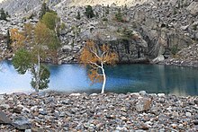
Three of the world's longest glaciers outside the polar regions are found in Gilgit-Baltistan: the Biafo Glacier, the Baltoro Glacier, and the Batura Glacier. There are, in addition, several high-altitude lakes in Gilgit-Baltistan:
- Sheosar Lake in the Deosai Plains, Skardu
- Naltar lakes in the Naltar Valley, Gilgit
- Satpara Tso Lake in Skardu, Baltistan
- Katzura Tso Lake in Skardu, Baltistan
- Zharba Tso Lake in Shigar, Baltistan
- Phoroq Tso Lake in Skardu, Baltistan
- Lake Kharfak in Gangche, Baltistan
- Byarsa Tso Lake in Gultari, Astore
- Borith Lake in Gojal, upper Hunza, Gilgit
- Rama Lake near Astore
- Rush Lake near Nagar, Gilgit
- Kromber Lake at Kromber Pass, Ishkoman Valley, Ghizer District
- Barodaroksh Lake in Bar Valley, Nagar
- Ghorashi Lake in Ghandus Valley, Kharmang
The Deosai Plains are located above the tree line and constitute the second-highest plateau in the world after Tibet, at 4,115 metres (13,501 ft). The plateau lies east of Astore, south of Skardu and west of Ladakh. The area was declared as a national park in 1993. The Deosai Plains cover an area of almost 5,000 square kilometres (1,900 sq mi). For over half the year (between September and May), Deosai is snow-bound and cut off from rest of Astore and Baltistan in winters. The village of Deosai lies close to Chilum chokki and is connected with the Kargil district of Ladakh through an all-weather road.


Rock art and petroglyphs
There are more than 50,000 pieces of rock art (petroglyphs) and inscriptions all along the Karakoram Highway in Gilgit-Baltistan, concentrated at ten major sites between Hunza and Shatial. The carvings were left by invaders, traders, and pilgrims who passed along the trade route, as well as by locals. The earliest date back to between 5000 and 1000 BCE, showing single animals, triangular men and hunting scenes in which the animals are larger than the hunters. These carvings were pecked into the rock with stone tools and are covered with a thick patina that proves their age.
The ethnologist Karl Jettmar has pieced together the history of the area from inscriptions and recorded his findings in Rock Carvings and Inscriptions in the Northern Areas of Pakistan[117] and the later-released Between Gandhara and the Silk Roads — Rock Carvings Along the Karakoram Highway.[118] Many of these carvings and inscriptions will be inundated and/or destroyed when the planned Basha-Diamir dam is built and the Karakoram Highway is widened.
Climate
The climate of Gilgit-Baltistan varies from region to region, since the surrounding mountain ranges create sharp variations in weather. The eastern part has the moist zone of the western Himalayas, but going toward Karakoram and Hindu Kush, the climate gets considerably drier.[119]
There are towns like Gilgit and Chilas that are very hot during the day in summer yet cold at night and valleys like Astore, Khaplu, Yasin, Hunza, and Nagar, where the temperatures are cold even in summer.[120]
Economy and resources

The economy of the region is primarily based on a traditional trade route, the historic Silk Road. The China Trade Organization forum led the people of the area to actively invest and learn modern trade know-how from their Chinese neighbour, Xinjiang.[citation needed] Later, the establishment of a chamber of commerce and the Sust dry port in Gojal Hunza are milestones. The rest of the economy is shouldered by mainly agriculture and tourism. Agricultural products are wheat, corn (maize), barley, and fruits. Tourism is mostly in trekking and mountaineering, and this industry is growing in importance.[121][122]
In early September 2009, Pakistan signed an agreement with the People's Republic of China for a major energy project in Gilgit-Baltistan which includes the construction of a 7,000-megawatt dam at Bunji in the Astore District.[109]
Mountaineering


Gilgit-Baltistan is home to more than 20 peaks of over 6,100 metres (20,000 ft), including K-2 the second highest mountain on Earth.[124] Other well known peaks include Masherbrum (also known as K1), Broad Peak, Hidden Peak, Gasherbrum II, Gasherbrum IV, and Chogolisa, situated in Khaplu Valley. The following peaks have so far been scaled by various expeditions:


Tourism


Gilgit Baltistan is the capital of tourism in Pakistan. Gilgit Baltistan is home to some of the highest peaks in the world, including K2 the second highest peak in the world. Gilgit Baltistan's landscape includes mountains, lakes, glaciers and valleys. Gilgit Baltistan is not only known for its mountains — it is also visited for its landmarks, culture, history and people.[125] K2 Basecamp, Deosai, Naltar, Fairy Meadows Bagrot Valley and Hushe valley are common places to visit in Gilgit Baltistan.[126]
Transport

Before 1978, Gilgit-Baltistan was cut off from the rest of the Pakistan and the world due to the harsh terrain and the lack of accessible roads. All of the roads to the south opened toward the Pakistan-administered state of Azad Kashmir and to the southeast toward the present-day Indian-administered Jammu and Kashmir. During the summer, people could walk across the mountain passes to travel to Rawalpindi. The fastest way to travel was by air, but air travel was accessible only to a few privileged local people and to Pakistani military and civilian officials. Then, with the assistance of the Chinese government, Pakistan began construction of the Karakoram Highway (KKH), which was completed in 1978. The journey from Rawalpindi / Islamabad to Gilgit takes approximately 20 to 24 hours.
The Karakoram Highway connects Islamabad to Gilgit and Skardu, which are the two major hubs for mountaineering expeditions in Gilgit-Baltistan. Northern Areas Transport Corporation (NATCO) offers bus and jeep transport service to the two hubs and several other popular destinations, lakes, and glaciers in the area. Landslides on the Karakoram Highway are very common. The Karakoram Highway connects Gilgit to Tashkurgan Town, Kashgar, China via Sust, the customs and health-inspection post on the Gilgit-Baltistan side, and the Khunjerab Pass, the highest paved international border crossing in the world at 4,693 metres (15,397 ft).
In March 2006, the respective governments announced that, commencing on 1 June 2006, a thrice-weekly bus service would begin across the boundary from Gilgit to Kashgar and road-widening work would begin at 600 kilometres (370 mi) of the Karakoram Highway. There would also be one daily bus in each direction between the Sust and Taxkorgan border areas of the two political entities.[127]

Pakistan International Airlines used to fly a Fokker F27 Friendship daily between Gilgit Airport and Benazir Bhutto International Airport. The flying time was approximately 50 minutes, and the flight was one of the most scenic in the world, as its route passed over Nanga Parbat, a mountain whose peak is higher than the aircraft's cruising altitude. However, the Fokker F27 was retired after a crash at Multan in 2006. Currently, flights are being operated by PIA to Gilgit on the brand-new ATR 42–500, which was purchased in 2006. With the new plane, the cancellation of flights is much less frequent. Pakistan International Airlines also offers regular flights of a Boeing 737 between Skardu and Islamabad. All flights are subject to weather clearance; in winter, flights are often delayed by several days.
A railway through the region has been proposed; see Khunjerab Railway for details

No comments: